The Waldo Canyon Fire burning near Colorado Springs may be 90 percent contained, but it has left a scar on the state that will be viewable for years to come.
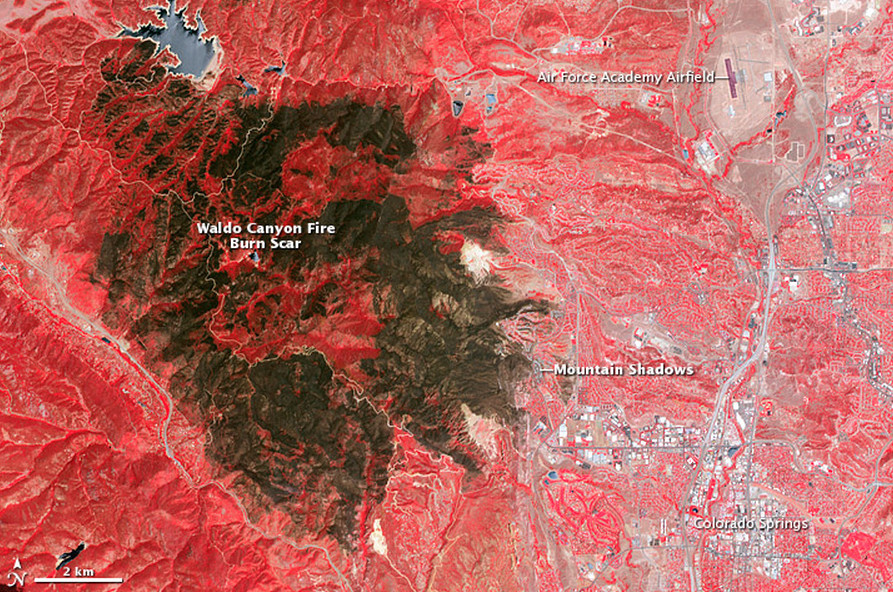
On July 4th, NASA's Advanced Spaceborne Thermal Emission and Reflection Radiometer (ASTER) snapped this breathtaking shot of the Waldo Canyon Fire burn scar in Pike's National Forest.
(SCROLL DOWN FOR NASA PHOTO)
According to NASA Earth Observatory the bright red, which includes both visible and infrared light in the false-color image, represents unburned forest and vegetation. The light brown areas indicate areas where some burning took place and the dark brown areas indicate areas severely burned.
The Waldo Canyon Fire burning since June 23rd is already the most destructive wildfire in state history. The fire forced the evacuation of at least 32,000 residents, has consumed 18,274 acres, destroyed nearly 350 homes and killed at least two people.
The toll for the damaged homes alone has reached $110 million, according to The Denver Post, and the total cost to fight the fire reached $14.5 million on Thursday. President Obama, who declared that the Colorado wildfires are a "major disaster," pledged federal aid to the state..
Days of record heat, high winds and unseasonable dryness produced a surge of fires burning throughout Colorado, providing devastating growth conditions. As many asten major fires were burning aroud the state in late June, all part of the worst wildfire season ina decade.
LOOK at satellite image of burn scar, via NASA Earth Observatory:
Edited By Cen Fox Post Team